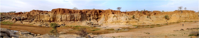
Fig. 1 The right bank of the Yamé River, between the Ravin du Hibou and the Ravin de la Mouche sites. Photo L.Lespez
General research aims
This part of the project was carried out in the framework of paleoenvironmental studies led by a group of researchers from the Universities of Caen, Frankfurt, Angers and Rouen. Folowing an approach simultaneously based on geomorphology, sedimentology and geoarchaeology, this research focuses primarily on understanding of changes in the fluvial landscapes of the Yamé over the course of the last ten millennia.
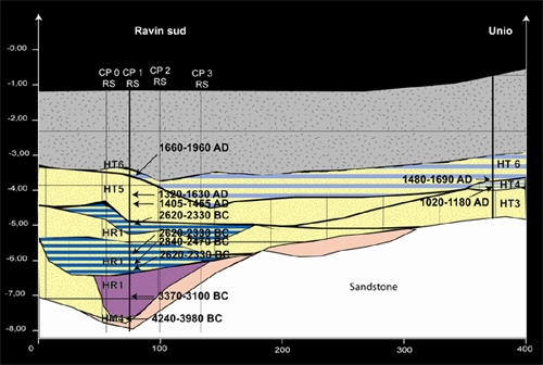
Fig. 2 Synthetic longitudinal profile of the Ravin sud (Right bank of the Yamé River). Photo L.Lespez
The objective is threefold. First, the aim is to establish a general chronostratigraphic framework which can be used by archaeologists and specialists in paleobiological analyses. Next, the goal is to understand the effect of paleoclimatic oscillations on the functioning of the water course and to deduce their consequences for local societies. Finally, it is then possible to contribute to the discussion on the impact of societies in humid zones of the Yamé Valley and more generally on the environments on the Bandiagara Plateau over the last twelve millennia.
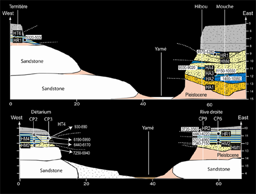
Fig. 3. Synthetic transverse profile of the Yamé River. CAD L.Lespez
Approach, methodology and preliminary results
In Sudano-Sahelian West Africa, the climate has an overall zonal distribution, primarily regulated by the displacement of the Intertropical Zone of Convergence (ITZC) in response to seasonal changes in maximum sun insolation. In winter, the southern migration of the ITZC subjects the regions to the influence of Saharan high pressure systems and to a continental influx from the east, the Harmattan. In summer, the northern migration of the ITZC leads to the arrival of the monsoons responsible for precipitation in the rainy season. It is with regard to fluctuations in this zonal dynamic that changes in the fluvial system recorded by the Yamé Valley during the Holocene should be discussed.

Fig.4 Chronostratigrapic synthesis for the Holocene Yamé River deposits. CAD L. Lespez
Research first consisted in the systematic following, over several kilometres, of the stratigraphic limits of the Pleistocene and Holocene formations, with the precise drawing of over a hundred sections (fig. 1). This demonstrated the succession of 18 Holocene sequences, characterized by a specific organization of macro- and micro-sedimentary facies. Dates obtained by radiocarbon (AMS and conventional) on charcoal from the Holocene layers situate these different sequences with precision (fig. 2 & 3). Analysis of the different sedimentary facies is based on the study of observable characteristics in the field, as well as on particle size analyses made with a laser granulometer and micromorphological observations made on undisturbed sediment blocks collected directly from the sections studied. The latter yielded data on the internal structure of the sediments, and reflect a shift from the description of macro- to micro-facies.
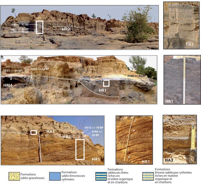
Fig.5 Chronostratigraphic synthesis for the Holocene Yamé river deposits
At present, the sedimentary record from the Yamé Valley is unique at the scale of West Africa. In effect, it offers a new sequence to analyze the effects of climatic change and the action of human societies on continental environments from the time of the first groups of pottery producers who frequented the Ravin de la Mouche more than 11,000 years ago (fig. 4 & 5). The precise understanding of the evolution of fluvial landscapes, along with the results of paleobiological studies, contributes to the definition of the resources available in the valley basin and its humid zones to the populations that successively occupied the Ounjougou sites. But since the fluvial system is a powerful spatial integrator, it also permits access to valid data at the scale of the valley slopes, that is, the slopes dominating the valley basin up to the Bandiagara Plateau.