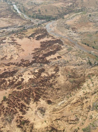
In this photo taken facing upstream, the Ounjougou ravines are easily identifiable in the sector of the confluence. We can also distinguish the protohistoric terrace (which directly overlooks the Yamé) from the upper glacis (foremost on the left). Aerial photo D. Gladsteen.)
The stratigraphic complexity of the formations in the Yamé Valley is not systematically reflected in the topography. At Ounjougou, the apparent monotony of the relief of the Dogon Plateau, mainly developed in Upper Precambrian conglomeratic sandstone, is interrupted by the increase in glacis and terraces cut in the fine formations of the Pleistocene and Holocene. Transversal profiles of the Yamé Valley are at once profiles associated with surface erosion of neighboring sectors of gravelly interfluves and an accumulation in the lower zones. It is thus the glacis of erosion and accumulation that are today forcefully incised.
Two main layers can be identified:
The principal glacis is that which forms the main part of the surface of the central part of the Dogon Plateau, gravely ensembles excepted. It is situated at altitudes of 400-440 m. It is both a glacis of erosion and accumulation, the deposition of which primarily reflects a broad period of remobilization of eolian silts at the beginning of the Holocene, deposited across the surface of the Dogon Plateau during the last arid maximum. At Kokolo and Oumounaama, many sections clearly demonstrate that these were colluvial deposits associated with a preceding erosion phase. At Ravin de la Vipère, the available OSL dates confirm this position: there is a chronological hiatus between the surface silts dated to the Holocene and the underlying Pleistocene silts (here earlier than 24 ka). This principal glacis dominates more than 20 m of the modern course of the Yamé and ends with a very clearly marked topographic rim.
The secondary glacis is spatially less well-represented and can be observed only near the water course. It is recorded several meters below the principal glacis and its development is responsible for the highly active erosion rim that led to the discovery of Middle Paleolithic tools at Kokolo, Dandoli and Sinkarma. An erosion glacis upstream, in the Pleistocene formations, several dozen meters lower it becomes a glacis-terrace and is then associated with the thick protohistoric fill that can be easily followed the length of the Yamé, the Boumbangou and the Ménié-Ménié. This deposit of yellow and red silts has been dated to between the 5th and 15th centuries AD (s.1) and forms a very clear terrace 8-10 m above the Yamé.

Quaternary stratigraphic units of Ounjougou. U=Pleistocene units, H= Holocene units. CAD M. Rasse
These two layers are topographically well-defined, but are not less complex for that. It is, in fact, quite difficult to identify surface micro-forms and a fortiori the limits of formations, particularly in the erosion/accumulation transition zone that is very subtle.
Locally moreover, the connection is interrupted by a third plane, much less visible in the landscape: this is a Neolithic terrace found at Damatoumou 4-5 m above the protohistoric layer. This is actually the only place, on the left bank of the Yamé just before the confluence, where this stage is topographically visible. On the opposite bank, the transition between the upper layer and the protohistoric fill is made by a convex surface in which bedded stream processes caused a very large number of lithic artifacts to be exposed (localized just above the Promontory site where bifacial arrow points were found).
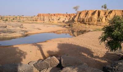
Immediately downstream from The Confluence, contact with the protohistoric terrace (at the top) is reflected by a terrace edge of 10 m, which evidences the strength of the recent incision. To the left in the background, the Oumounaama sector, more open and developed in the Pleistocene formations. Photo M. Rasse
Rare preservation in the Quaternary formations
At first sight, what is surprising at Ounjougou is the number of ravines and we note that this phenomenon is moreover extremely localized. In effect, both immediately downstream and upstream from the confluence of the Yamé and the Boumbangou, the valley has its normal form, wide, with shallow slopes in the surface deposits. At Bandiagara, several zones of surface erosion affect the upstream end of the lower glacis, suggesting the action of already “early” processes in the topo-sequences. At Ounjougou, in contrast, the topography is completely different. Gentle slopes in neighboring sectors contrast with the verticality of the topographic profile developed in recent formations and ravines became ubiquitous, extending along very large portions of the terrain. This thus suggests a phenomenon both localized and brutal that was initially difficult to place in context with what was known and commonly accepted in the landscape evolution by the combined causality of recent climate change and human action.
The explanation would certainly not have been determined without recourse to discussion with the nearest villagers, who related a catastrophic phenomenon that occurred during extremely rainy episodes in August 1936 (from the latest surveys by A. Mayor): in one night, the Yamé that flowed from a ridge currently at 402 m in altitude, adopted its modern course by completely changing the configuration of the site and the cultivated plots. The waterfall on the gravelly ridge, which the inhabitants remember, stopped functioning and its marshes, located up- and downstream from the sector that was brutally opened, both disappeared.
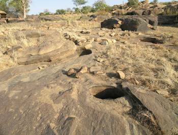
Evidence for hydrographic change occurring in 1936 is given by the paleovalley that the Yamé formerly followed. We note the erosion potholes, and also fluviatile polish showing hydrological activity. Photo M. Rasse
In addition to oral accounts, several geomorphological indices support this recent evolution. The ridge by which the paleocourse passed is located 9 m above the actual talweg, but 4-5 m below the protohistoric terrace, which was pro parte the cause of the sedimentary “chokepoint”. The altitudes of the dry valley are thus perfectly compatible with the hypothesis of this change. The path itself of the fluvial bed has located with great precision. It still has a strong freshness of forms: the erosion potholes suggest a powerful water course and the conglomeratic sandstones of the ridge have a quite specific fluviatile polish that cannot be found anywhere else in the valley.
It is thus now definite that geomorphological conditions changed, instantaneously, more than half a century ago. This was only a relatively innocuous self-capture, linked to regressive erosion of the stream that was established in the Oumounaama sector; but by abruptly changing its longitudinal profile, since there were no longer gravelly bars resisting its advance, the Yamé was embanked in the Pleistocene and Holocene formations, developing the gully erosion (ravines) that we see today. The Ravin sud, which rejoins the principal course at the level of the topographic ridge, was constrained to continue its course to the actual confluence, by reusing in the opposite direction part of the abandoned valley. This continuous erosion acted rapidly: comparison of photographic missions in 1952 and 1982 very clearly demonstrate the embanking of the network in the valley and the significant retreat of the ravine summits. Each rainy season contributes to this erosion – the abundant rains in recent years (especially in 2003 and 2007) caused efficient erosion. It is thus even more necessary to excavate here in upcoming years since it is probable that the sedimentary stock, and with it the archaeological material, will be seriously reduced in the next three or four decades.